Mývatnssveit
Mývatnssveit has a population of about 450, of which over 200 live in the urban area of Reykjahlíð. In previous years, Mývetningar's main occupation was related to agriculture and trout fishing in Mývatn, but in recent years there have been significant changes. There are many jobs in electricity production, but tourism has also been well established in Mývatnssveit for a long time. There are several hotels in the countryside, restaurants, campsites and other tourism-related businesses.
Nature baths in Mývatnssveit were opened in 2004. There are good fitting rooms, saunas and a hot tub. The lagoon itself has a very healing effect for people with psoriasis and other skin disorders.
The natural beauty of Lake Mývatn is unique, but volcanic eruptions have shaped the landscape there for centuries.
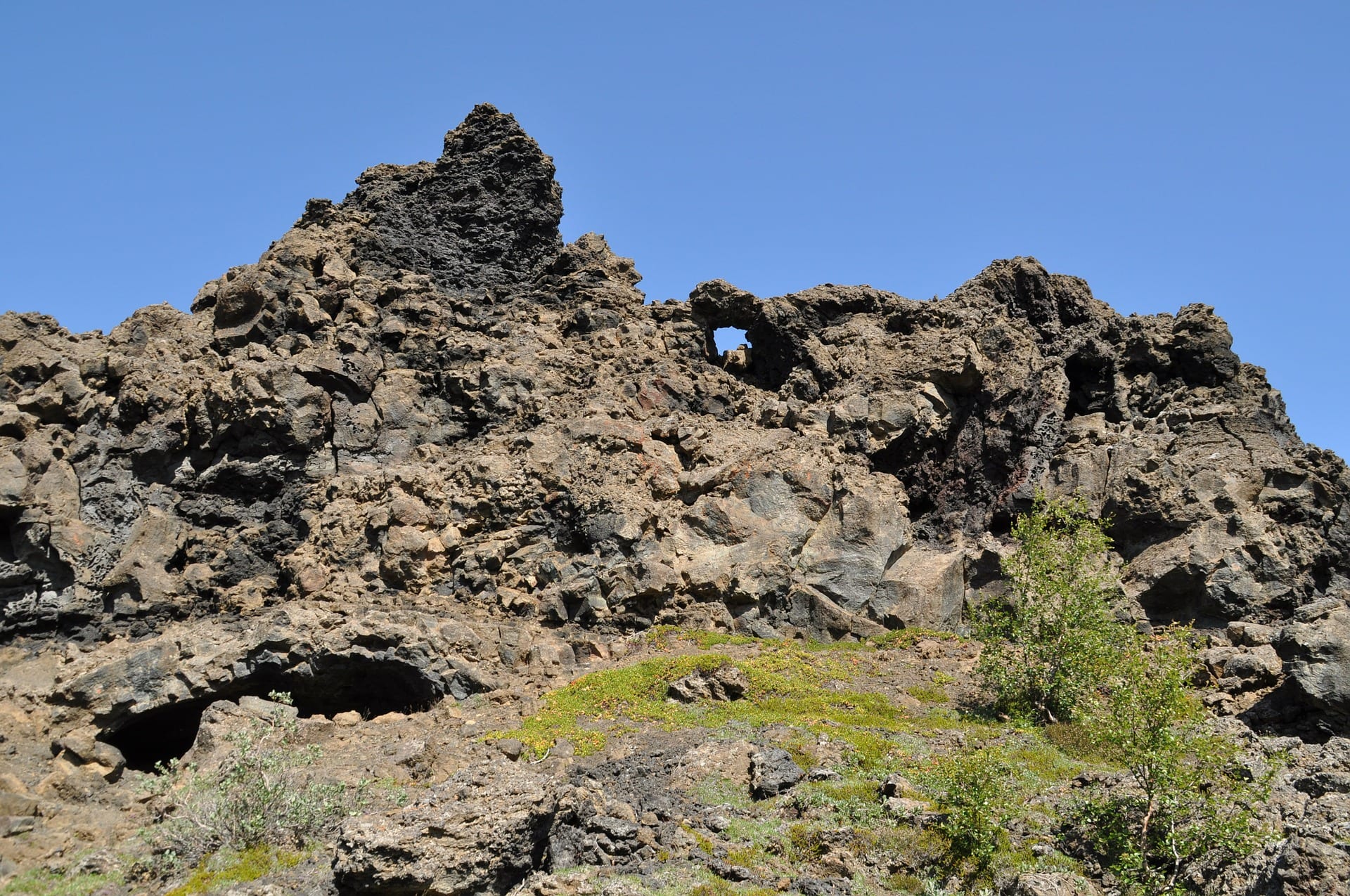
The lake is one of the largest lakes in Iceland, 36.5 km2 and is famous for its bird life. It is believed that more species of ducks live on Lake Mývatn than in any other place on earth. Mývatn derives its name from mývargi, but it is of two types, i.e. bitmý and rykmý. There is a risk that the natural environment would be different if there were no marshes, as the marsh is a large part of the food of various birds as well as trout. Dark cities are close to Hverfjall but they are fragmented lava cities with vegetation and bushes.
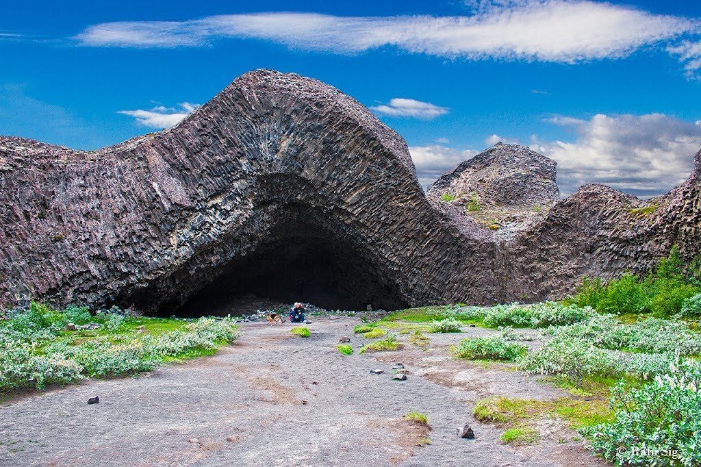
In Dimmuborgir you can see all kinds of strange pictures, perforated cliffs and small caves, the most famous is probably the Church, high and large dome, open at both ends.
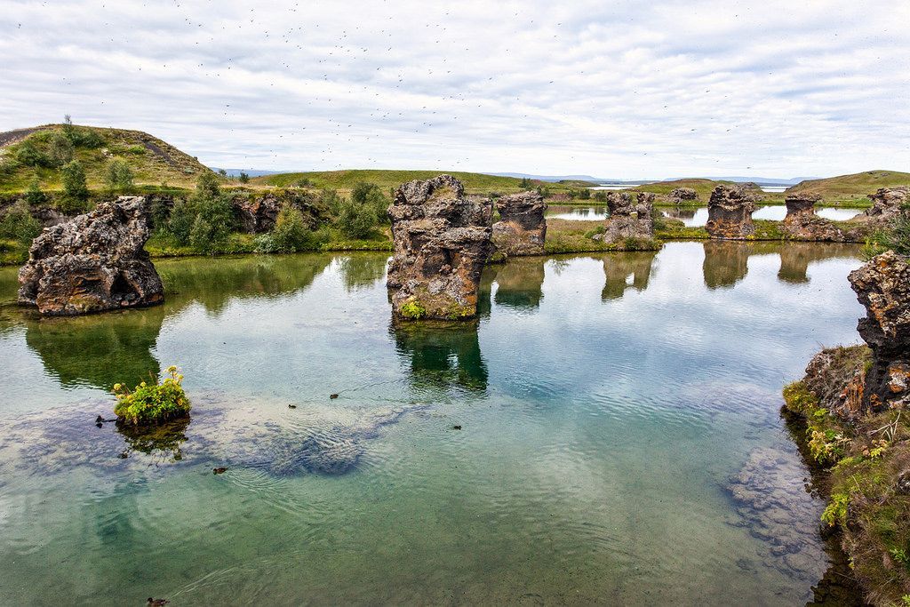
Höfði is a cliff that goes out into Lake Mývatn. There is a good view of Höfðan over Mývatn, its scales and bays and it is an ideal place for bird watching. Kálfastrandarvogur lies along Höfðan and is unique for lava formations in and around the scales. These ridges are called Klasar and Kálfastrandarstrípar, but Kálfastrandarvogur and the surroundings of Höfði are considered to be the most beautiful places by Lake Mývatn.
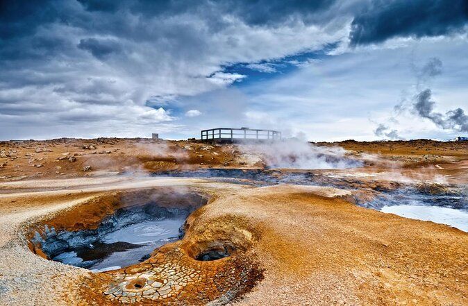
Skútustaðagígar (craters) are a popular place for bird watching and are protected as natural monuments. Mining Mountain is a high temperature area and the temperature is over 200 ° C at a depth of 1000 meters. There are two types of hot springs, steam hot springs and clay hot springs. In the high temperature area, the soil is barren and barren, but due to the influence of the thermal air, it is very acidic. There is considerable sulfur precipitation from the hot springs and there was significant sulfur mining at
Námafjall in earlier centuries. The owners of Reykjahlíð became very rich in the sale of sulfur in the Middle Ages, but it was used in powder making. The geothermal area was like the whole of Skútustaðahreppur, protected in 1974. There is reason to warn people about unreliable soil and high temperatures (80-120 ° C).
In Leirhnjúkur, there have been two major fires in the last two centuries. Mývatn eruptions 1724-1729 and the second time so-called Krafla eruptions which began in 1975. In Leirhnjúkur you can still find the heat in the 15 year old lava, but there are also large sulfur mines and color splendor in most places. about 300 m in diameter. The crater was created by a violent eruption in 1724. With it began the Mývatn eruptions, which lasted more or less continuously for five years and is the longest eruption in Iceland's eruption history known. For more than a century after the eruption, hot clay porridge was boiled in Víti, but now it has long since cooled down.
Hverfjall has a large, circular crater, about 140 m deep and about 1000 m in diameter. Hverfjall is one of the most beautiful and regular explosive crater images that can be seen in Iceland and considered one of the largest of its kind on earth. It can be considered certain that the crater was formed during an explosive eruption and its age is estimated at 2500 years. .
The mountain Herðubreið, which often goes by the name Queen of Icelandic Mountains. Herðubreið is a tuff cliff and rises 1000-1100 m over the lava field around, steep and round cliff belt at the top. The mountain is so regular, clean in lines and beautifully created that it can hardly be found in Icelandic mountaineering. At the foot of Herðubreið are Herðubreiðarlindir, a vegetation at the edge of Ódáðahraun, where many springs emerge from the lava rim and merge, in many places with waterfalls. Herðubreiðarlindir is considered by many to be one of the most beautiful spots in the wilderness of the country, especially due to the views and contrasts of nature that appear there. Herðubreið and its surroundings were protected in 1974.
Askja is a large, oval-shaped sinkhole and contains Öskjuvatn, which is the deepest lake in Iceland, or 217 m where it is deepest. There are many large volcanoes in Askja. The largest crater is Víti, which spewed ash and pumice in 1875. The water in the crater is still about 22 degrees hot and it is popular to bathe in it. It will be unforgettable for everyone who comes to Askja. The greatness of nature and the smallness of man are shown in it unusually clearly. Pálmi Hannesson, former rector of MR, said: "I believe that Askja is the strangest place in this strange land. And I pretend to know that on all the earth there are few places as magnificent and formidable as it is, and I know that each he who has once seen her will never forget her again.
"The national park in Jökulsárgljúfur is known for its famous beauty and natural wonders. There are three waterfalls in Jökulsárgljúfur, Dettifoss, Selfoss and Hafragilsfoss, but Dettifoss is the most powerful waterfall in Europe, 44 m high and 100 m wide.
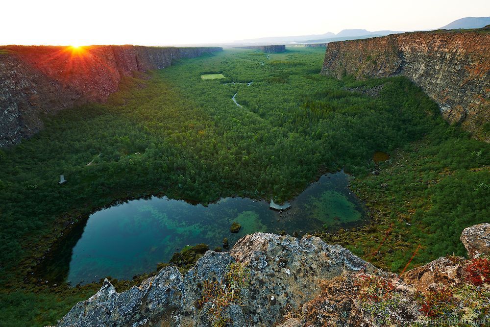
Ásbyrgi is a magnificent natural phenomenon with about 90-100 m high rock walls. There is a pond, Botnstjörn with lush vegetation all around. There is a large birch forest around Ásbyrgi and it is protected by the State Forestry. There have been various hypotheses about the formation of Ásbyrgi, but now it is considered certain that it was caused by two catastrophic eruptions in Jökulsá, the first 8-10 thousand years ago and the second eruption almost three thousand years ago. Jökulsá then changed its channel and has since flowed along the current channel. Legend has it that Ásbyrgi is a hoof after Sleipnir, Óðinn's horse, and the island is followed by the hoof tongue. In the lush Hólmatungur there are many beautiful stalactite formations. It is said by many that there is no more beautiful hiking area in the country than between
Hljóðaklettar and Hólmatungur along Jökulsá á Fjöllum. Countless springs spring up in Hólmatungar and the water falls stall by stall down into Jökla. On the hiking trail, just south of Tungnar, there is a so-called Gloppuhellir in Gloppa, which is a special natural creation. North of Hólmatungur are Ytra- and Syðra-Þórunnarfjall. Legend has it that Þórunn ríka in Ás in Kelduhverfi fled there when black death swept over the country. There she lived with her family, until food shortages began to take their toll. It was not until the shepherd had been slaughtered that the people had something to eat that Þórunn, who was very tall, went to the settlements, because she feared that she would be next on the menu. Sound cliffs are a peculiar and worth seeing cluster of rocks. Sound cliffs are remnants of volcanoes and Jökulsá á Fjöllum has destroyed the slag crater so that there are beautifully supported rock formations. There are caves and boats and gender-based stingrays where the stingrays lie in various ways.
Húsavík is one of the most well-known towns in the country for whale watching, where the Whale Museum has extensive and clear information about whales and whaling in Iceland.